Independent field guide
Bow River running very high at Lake Louise as wet weather continues
Last updated:
Lake Louise is in a sensitive river and trail period after warm weather, snowmelt and fresh precipitation pushed local streams higher across the upper Bow headwaters.
According to provisional real-time data from the Water Survey of Canada, the Bow River at Lake Louise was reading 72.4 m³/s and 2.502 m late Sunday, May 31. That is above the same gauge’s 2013 instantaneous annual peak of 66.2 m³/s and 2.353 m, recorded on June 21, 2013.
The nearby Pipestone River is telling a different story. Water Survey of Canada data showed the Pipestone River near Lake Louise at 45.7 m³/s and 1.410 m. That remains well below its 2013 peak of 144 m³/s and 1.961 m, recorded on June 20, 2013.
That distinction matters. This is not a simple repeat of 2013 across all nearby streams. The Bow near Lake Louise is exceptionally high by recent local comparison. The Pipestone is elevated, but it has not approached its 2013 flood peak.
According to Alberta River Basins and Alberta Environment and Protected Areas, a Flood Watch remains in place for the Bow River near Lake Louise and the Pipestone River near Lake Louise. The provincial River Forecast Centre also says the Bow River Basin is above normal, with active advisories across several Alberta basins.
Rain, snow and the freezing level
Alberta River Basins station data shows the recent storm has been wet at both high-elevation monitoring sites.
At Pika Run, the latest table showed about 52.5 mm of precipitation over 120 hours, including about 35.7 mm in the latest 24 hours available. Source: Pika Run - EPA precipitation data.
At Skoki Lodge, the latest table showed about 34.2 mm over 120 hours, including about 27.5 mm in the latest 24 hours available. Source: Skoki Lodge - EPA precipitation data.
The freezing level is part of the story. Earlier warm temperatures helped drive snowmelt and raise river levels. During the current storm, colder air and lower snow levels mean some precipitation is falling as snow at higher elevations instead of immediately running off as rain.
Environment Canada’s Bow Valley forecast referenced a snow level near 2,100 m lowering toward valley bottom. Open-Meteo forecasts for the Pika and Skoki elevations also show part of the upcoming precipitation falling as snow.
That can reduce immediate runoff for a time, but it does not remove the risk. Fresh snow can melt quickly if temperatures rebound. Rain falling later on new or existing snowpack can still produce a fast river response.
Could this happen again this season?
Yes, it is possible.
That does not mean Lake Louise should expect another event of the same size this season. The public information reviewed for this story is not enough to assign a probability. But the setup that matters can still happen during the remaining snowmelt season: a wet storm, a high freezing level and enough upper-elevation snow left to melt.
That is the combination that made the 2013 flood so damaging. The June 19 to 22, 2013 event was a later-June rain-on-snow flood, with heavy rain falling high into the alpine snowpack while freezing levels were elevated. That added snowmelt runoff to direct rainfall runoff. Source: Canadian Water Resources Journal research on the 2013 flood.
The current event is different because some high-elevation precipitation is forecast as snow. That may slow the immediate runoff response. But it also leaves more water stored in the upper basin. If that snow is followed by a warm spell or another wet storm with a higher freezing level, the Bow and nearby streams could rise again.
Parks Canada’s current Banff trail conditions support that caution. The Lake Louise area report warns that trails are covered with snow and ice, with hazards including slipping, post-holing, difficult route finding and avalanche risk. Several classic higher routes remain snowbound, not recommended, avalanche terrain or without access.
So the honest answer is this: the current high water may ease, but the seasonal risk window is not closed. Another high-water pulse is possible if the weather turns warm and wet again.
How this compares with 2013
The 2013 flood was a later-June rain-on-snow event. Published hydrology studies describe the June 19 to 22, 2013 storm as heavy rain combined with rapidly melting alpine snow. Freezing levels were high, near 3.5 km above sea level, which allowed rain to fall high into the alpine snowpack.
That added snowmelt runoff to direct rainfall runoff. Source: Canadian Water Resources Journal.
For the Pika and Skoki sites, the public Alberta station CSVs reviewed for this story did not expose 2013 observed precipitation. As a comparison only, Open-Meteo historical reanalysis estimates about 62.5 mm near Pika and Skoki from June 18 to 22, 2013, including about 55.3 mm from June 19 to 21. That is a model estimate, not a gauge record. Source: Open-Meteo historical weather API.
The current event is different because some high-elevation precipitation is forecast as snow. The risk window is not closed, though. A later-season setup like 2013 can still happen if three ingredients line up: a wet storm, high freezing levels and enough remaining alpine snowpack to melt.
Recent peak comparisons
Water Survey of Canada annual peak data since 2013 shows the Bow River at Lake Louise has come close to its 2013 peak several times. Source: WaterOffice historical hydrometric data.
| Year | Peak flow |
|---|---|
| 2013 | 66.2 m³/s |
| 2017 | 64.7 m³/s |
| 2021 | 64.3 m³/s |
| 2020 | 60.1 m³/s |
| 2014 | 58.8 m³/s |
The current provisional Bow reading of 72.4 m³/s is above those listed annual peaks.
For the Pipestone River near Lake Louise, 2013 remains the clear outlier.
| Year | Peak flow |
|---|---|
| 2013 | 144 m³/s |
| 2020 | 57.9 m³/s |
| 2021 | 54.8 m³/s |
| 2017 | 50.3 m³/s |
| 2015 | 49.6 m³/s |
The current provisional Pipestone reading of 45.7 m³/s is elevated, but not close to 2013.
Forecast uncertainty
Open-Meteo multi-model guidance near Lake Louise shows a wide spread.
For the next 72 hours, model totals ranged from roughly 0.3 mm to 24.1 mm. For the next seven days, totals ranged from about 13.5 mm to 34.6 mm. Source: Open-Meteo forecast API.
Alberta’s River Forecast Centre is carrying a broader regional forecast of 30 to 60 mm for the Bow headwaters through Wednesday, June 3, with snow expected at higher elevations. Source: Alberta River Basins forecaster comments.
Local amounts can vary sharply with elevation, storm track and convective bands.
Trails, closures and bulletins
The river story is not separate from the trail story.
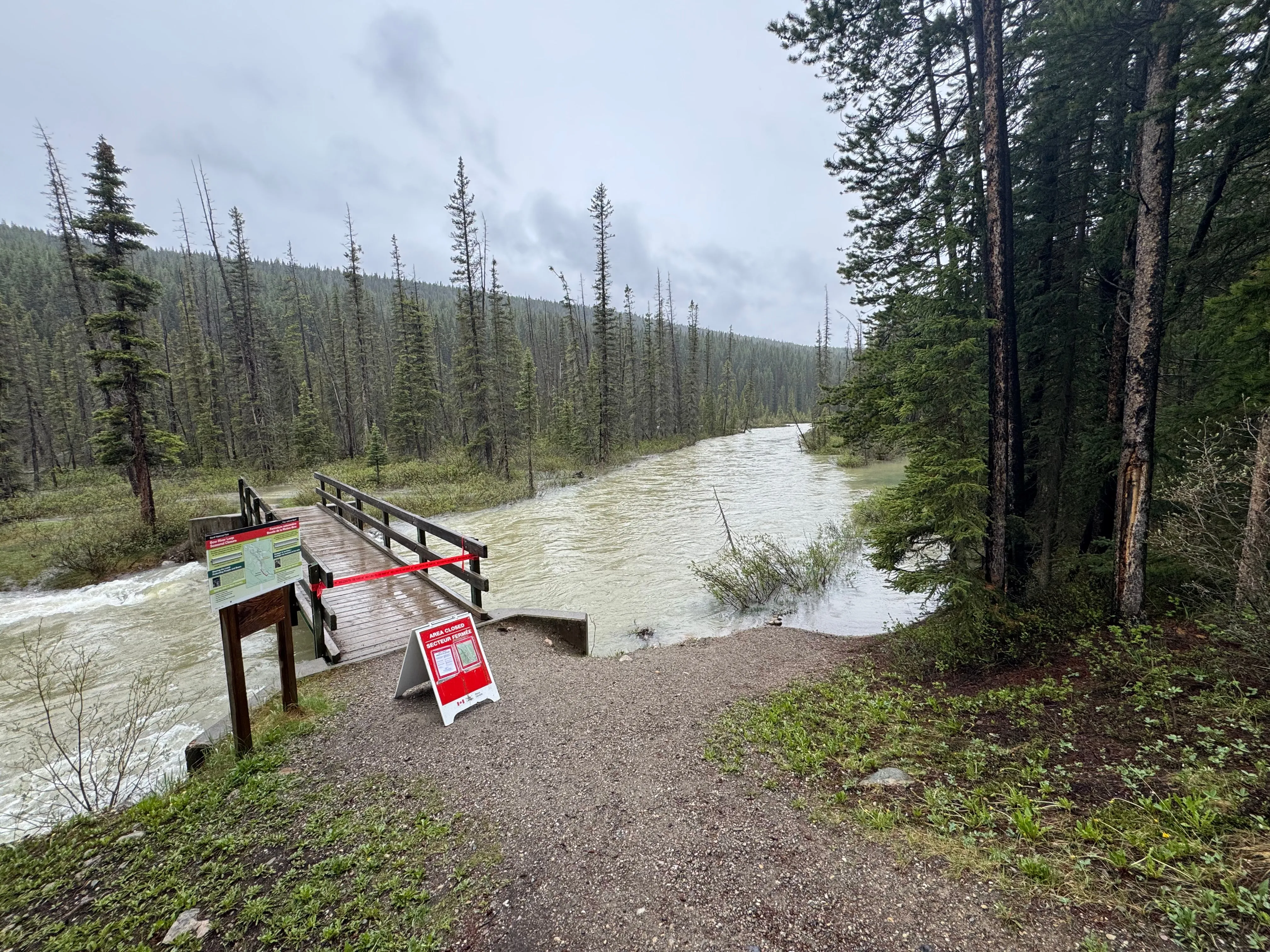
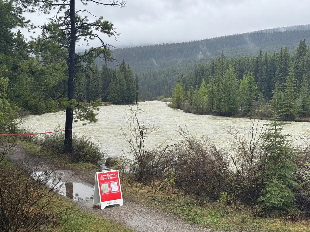
A closed bridge and trail access point near Lake Louise, where high water has pushed into low-lying areas along the river. Photo: LakeLoui.se / local field observation.
Parks Canada’s current Banff trail conditions warn that Lake Louise area trails are covered with snow and ice, with hazards including slipping, post-holing, difficult route finding and avalanche risk. The same page notes that space is limited, paid parking is in effect at Lake Louise, Moraine Lake Road is closed to personal vehicles year-round, and Parks Canada shuttle bookings should be checked through the official reservation system.
Closer to the village, the Bow River trail is listed as partially closed, with flooded sections, wet and muddy conditions, high river caution and a seasonal closure along the southwest side of the Bow River. Louise Creek Trail is also listed as partially closed, with the lower section closed from May 15 to October 15 to protect wildlife habitat.
The Lake Louise Lakeshore Trail is listed as fair, with wet and muddy sections and avalanche risk beyond the end of Lake Louise.
Higher routes remain a poor bet. Parks lists Lake Agnes, Little Beehive, Big Beehive, Plain of Six Glaciers, Saddleback Pass and Fairview Mountain with avalanche terrain, snowbound conditions, not-recommended language or not-yet-maintained notes. Several Moraine Lake area trails are still listed as no access or not recommended.
Parks Canada has also posted an area closure for trails and areas adjacent to the Pipestone River in Lake Louise because of high water. The closure was issued May 28 to protect visitor safety in areas affected by high water.
A separate Lake Louise area trail closure remains in effect from May 15 to October 15 for several village-to-lakeshore corridor sections, including parts of Bow River Trail, Louise Creek Trail, the lower Tramline area and the Great Divide Trail parking lot, to protect an important wildlife travel corridor.
Other current bulletins still matter for visitors. Parks Canada lists restrictions on paddling, fishing, scuba diving and other non-motorized water activities under its aquatic invasive species prevention rules. Lake Louise is listed in the Water Recreation Zone, where several water activities require a valid self-certification permit, while Moraine Lake and the Pipestone River are listed in the Water Preservation Zone, where paddling and floating are prohibited.
Moraine Lake Road remains restricted to most motor vehicles, with exceptions for Parks Canada shuttles, licensed commercial operators, Moraine Lake Lodge access, staff, contractors and emergency services.
Lake Louise Trailer Campground is also closed to tents, tent trailers and units with soft-sided pop-outs because of seasonal bear activity. Source: Parks Canada Banff camping information.
Trail and visitor message
Trail users should expect wet, muddy, snowy or locally flooded conditions, especially near rivers, bridges, creek crossings, campground edges and low-lying paths.
Stay back from fast water and eroding banks. Obey closures, posted notices and safety fencing. Do not treat current conditions as stable.
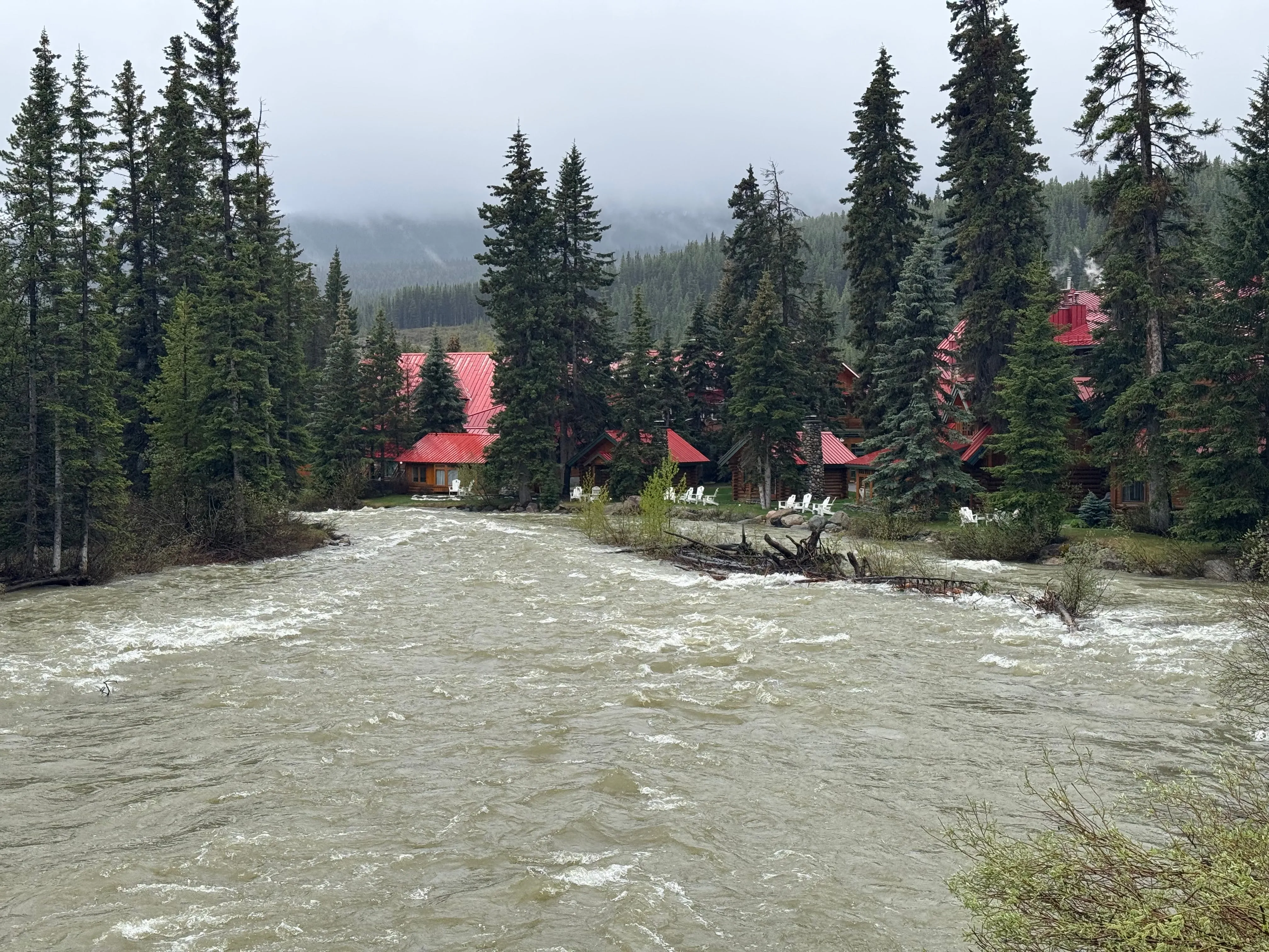
Elevated flows move through the Post Hotel area in Lake Louise during the current high-water period. Photo: LakeLoui.se / local field observation.
LakeLoui.se has observed Tiger Dams and sandbags around public infrastructure in Lake Louise. The measures appear precautionary and show elevated water levels are being taken seriously while conditions continue to change.
Guests, residents and businesses should sign up for Voyent Alert and continue monitoring Parks Canada, Alberta Rivers, Environment Canada and local emergency channels.